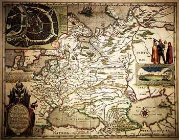
Tabula Russiae ex autographo,
quod delineandum curavit Foedor filius Tzaris Boris desumta; et ad fluvias,
Dwinam, Zuchanam, aliaque Loca, quantum ex tabulis et notitus ad nos delatis
fieri poluit, amplificata: ac Magno Domino, Tzari, et Magno Duci Michael
Foedrowits omnium Russorum Autocratori Wolodimeriae, Moscoviae et Novogardiae,
Tzari Cazaniae, Tzari Astracaniae, Tzari Sibiriaeģ Dedicato ab Hesselo
Gerardo M.DC.XIII. [Amsterdam], 1613.
1 sh., 42x54 (50x60). Engrav.
Map of Russia is made up by the known Netherlandish geographer
and cartographer Hessel Herrits. The map was published in Amsterdam in
1614. It is noted in its cartouche that it is performed according to autograph
of czarevitch Fedor Borisovich Godunov, as well as according to maps and
information which he could get additionally. Northeastern part of the map
is brought to the Pyasina river. The Teneseya (Yenisei) river is shown
to the westward from the river Pyasina. The Ob river is shown rising from
the Kitaika lake. A part of Novaya Zemlya is shown conventionally.
In catologue
|
|
