Maps and bibliographical description
|
1 sh. 54x89 (69x97). Engrav. Colour.
In catologue |
|
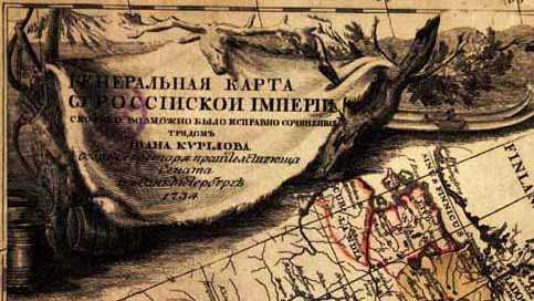
S I B E R I A M A P P I N G Maps and bibliographical description
General map of Russian Empire compiled as much diligently as possible by Ivan Kirilov, a chief-secretary of the Senate, in Saint Petersburg in 1734. [G.I.Unverzaht, Engraver. St.Petersburg, 1734] 1 sh. 54x89 (69x97). Engrav. Colour.
It is the first review geographical map of Russian Empire. When compiling it, Ivan Kirilov used the maps made up by geodesists-participants of cartographic and geodetic works which were carried out in Russia since 1721 and all achievements of Russian cartography known to him at that time. The materials of the First Expedition of Vitus Bering to Kamchatka were also included in the map. When compiling the map
the disagreement in the maps of provinces and uyezds with each other became apparent which resulted from the insufficient number of reference geodetic points. So the map overstated the extension of the country in longitude for 7-8?. The general map of Russian Empire made up by Kirilov were widely used both in Russia and abroad and served as a source for compiling a number of maps included in atlases made up by Homan, Rober de Vagondi and so on.
In catologue
![General map of Russian Empire... [SPb., 1734]. (258 KB)](k8.jpg)